
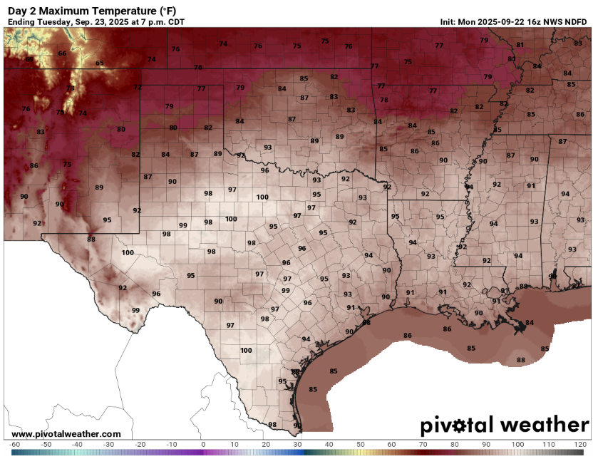
The autumnal equinox arrived Monday, but Mother Nature isn’t ready to give up the Texas heat and let us dive into all things pumpkin spice just yet. Austin is still stuck in summer mode, with afternoon temperatures approaching 100 degrees on Tuesday.
A ridge of high atmospheric pressure holds on for one more day before a midweek cold front brings a good chance of rain and a noticeable cooling in air temperatures.
Until then, the headline is the heat, accompanied by breezy southerly winds, muggy sunshine and daytime temperatures peaking near 99 degrees. But humidity could make those temps feel more like 102 to 105 degrees across Central Texas. Conditions could meet the National Weather Service’s criteria for a heat advisory, especially for areas east of Austin, so be sure to take breaks if you work outside and drink plenty of water.
We’ve tallied 21 days of triple-digit temperatures so far this year and could be close to adding another on Tuesday.
Luckily, a cooldown is only a day away, when the ridge of high pressure will push south into Mexico and get replaced by a cold front that should move into Central Texas by Wednesday morning. This will lead to showers and thunderstorms developing near Waco early in the day, then spreading south into Austin through the afternoon and evening.
With significant atmospheric moisture flowing in from the Gulf of Mexico already in place, moderate to heavy rainfall is likely with the passage of the front, along with a low-end threat of severe weather. The weather service’s Storm Prediction Center has placed Central Texas under a level 1 of 5 for severe weather, which means isolated but brief thunderstorms are possible. Flood forecasters at weather service’s Weather Prediction Center also have parts of Central Texas east of Interstate 35 under a level 1 of 4 risk, or at least a 5% chance, for flash flooding.
The best window for rain is from noon Wednesday through early Thursday morning with 70% coverage. Totals could range from a half-inch to 2 inches. Most forecast models keep some rain around Thursday as the boundary of the front moves slowly, but rain chances drop to about 20% across the Austin metro area. The focus of the heavier rainfall will be from San Antonio to Houston, extending south to Corpus Christi.
The front will push to the Rio Grande, bringing north winds and drier air into Central Texas. Temperatures behind the front will be cooler than the seasonal normal of 90 degrees and 69 degrees for the rest of the week.
Beyond this week, a more active pattern is expected late September into early October with more Pacific moisture flowing into the region. The weather service’s Climate Prediction Center’s six- to 10-day and eight- to 14-day outlooks show a 30% to 50% chance of above-average precipitation.