

Sunday evening weather forecast
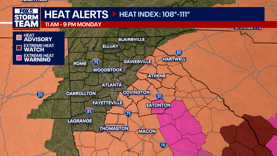
Heat warning are in place for parts of the area on Monday. Storm chances increase mid-week, which will cool us down for a few days.
ATANTA – A hot weekend will set the stage for an even hotter week ahead, according to FOX 5 Storm Team Meteorologist Alex Forbes.
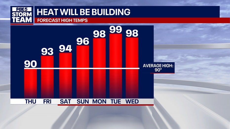
Temperatures will climb into the mid-90s by Sunday. By Monday, the heat is expected to intensify, pushing into record-breaking territory. As a result, several heat warnings and advisories are in place.
RELATED: Blistering temps on the way for North Georgia: Know how to stay cool
What we know:
The peak of the heat wave is expected Monday and Tuesday, when temperatures could flirt with 100 degrees in parts of metro Atlanta and North Georgia. Warm, muggy nights will provide little relief, with overnight lows remaining in the 70s.
On Sunday, the National Weather Service issued the first Extreme Heat Warning of the year in our area. Putnam County could reach 111 degrees on Monday. The warning extends further south into Milledgeville and Dublin.
RELATED: ‘Dog days of summer’ peaks this week: Intense heat and superstition
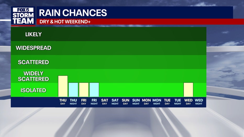
A better chance of afternoon storms may arrive by midweek, but the heat will remain a dominant factor through at least Thursday.
DOWNLOAD THE FOX LOCAL APP FOR THE LATEST FORECASTS
What they’re saying:
“By the time we get into your Thursday afternoon, we’ll see high temperatures pressing 90 again,” said FOX 5 Chief Meteorologist David Chandley. “Now we are looking at something major down the road… big time heat wave with highs approaching 100 here in Atlanta.”
Local perspective:
Atlanta: Highs will rise to 99 by Monday. Rain chances remain low, with only a 30% chance of afternoon storms through Friday.
Rome: Temperatures will climb to 98 on Monday, with scattered storms possible each afternoon.
LaGrange: Highs will move to the mid-90s by Monday. The highest chance of rain comes Thursday, with a 60% chance of storms.
Eatonton: Temperatures are forecast to reach 102 by Monday, with heat index values exceeding 100 as early as Thursday.
Athens: Highs will rise from 90 to near 100 through the weekend, with a daily chance of isolated storms.
Gainesville: Expect a steady increase in heat, peaking around 99 on Monday. Afternoon storms may offer brief relief.
Blairsville: Temperatures will remain slightly cooler than the rest of the region but still climb into the mid-90s by Monday, with daily chances of storms.
READ ALSO: National Hurricane Center watching disturbance in Gulf
What’s next:
Officials urge residents to prepare for prolonged heat by staying hydrated, limiting time outdoors during peak hours, and checking on elderly or vulnerable neighbors.
Cooling centers will be available in many communities.
The Source: The FOX 5 Storm Team and the National Weather Service provided the original forecast for this article.